Fact System
In the following we relate the system of fact finding by the scientific surveys with the legal acknowledgement of facts. We aim to point out a fact hierarchy and thereby also a method hierarchy.
The systematic use of facts will enable the reader to understand how the scientific methods are applied to the UNCLOS.
According to the Scientific and Technical Guidelines of the Commission on the Limits of the Continental Shelf (CLCS) the coastal states must submit one of five points of relevant supporting information and data in order to extend the outer limit of the continental shelf:
1. A line delineated at a distance of 60 m seaward from the foot of the continental slope (in accordance with article 76 (4) (a) (ii)); or:
2. A line along which the sediment thickness is 1 per cent of the shortest distance from the foot of the slope (in accordance with article 76 (4) (a) (i));
and not further than
3. A line delineated at a distance of 350 m from the baselines; or
4. A line delineated at a distance of 100 m from the 2,500 meters isobath; or
5. A limit agreed to by states with opposite or adjacent coasts (in accordance with article 83).
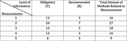
In the following overview table we have counted the number of criteria level (Y and R from the case code table) according to each of the five points of data:
The Commission (CLCS) may request each of the five points to be provided with information corresponding to a 30 point case code table.
This table explains by which methods each of the five measurements can be obtained. Besides listing the applied methods relating to the measurements, the table includes information on whether each method is obligatory, recommended or not obtainable according to the measurement in question.
A peek of the case code table is shown below:
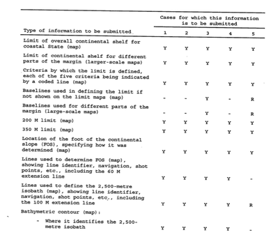
Explanation of overview table
This means that if one of the Arctic coastal states want to submit proof of the fourth type of measurement (of the five point of relevant information), the state needs to submit data sufficient to the case code of the 30 criteria points.
The table to the left summarizes the case code table with an overview of the number of methods ranked as obligatory, recommended and total. This shows us that some of the measurement points require more types of methods than others.
The Hierarchy of Facts
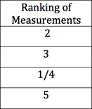
On the basis of the overview table above, we have ranked the five measurement points by the number of criteria that they need to fulfil. This ranking is the same whether based on the number of “Obligatory” methods or the total number of methods.
Assuming that for each measurement: the more criteria that need to be fulfilled the harder the measurement is to submit as well as the more criteria of the obligatory level of data the harder the measurement is to submit, then this scheme of ranking also becomes a fact hierarchy.
Assuming that for each measurement: the more criteria that need to be fulfilled the harder the measurement is to submit as well as the more criteria of the obligatory level of data the harder the measurement is to submit, then this scheme of ranking also becomes a fact hierarchy.
Danish facts
In order to put into perspective these categories of fact finding and fact proving provided by the CLCS we relate to the Danish Arctic research.
On the website of the Institute of Geological Surveys of Denmark and Greenlandlist of necessary and supporting data can be found. Looking at the list of corresponding to the CLCS Scientific and Technical Guidelines by the Commission on the Limits of the Continental Shelf.
Summarizing this means that the data should be:
Of the supplementing data is:
Read more about the necessary data and expeditions and fieldwork in the Danish polar expeditions on the website of the Institute of Geological Surveys of Denmark.
In order to put into perspective these categories of fact finding and fact proving provided by the CLCS we relate to the Danish Arctic research.
On the website of the Institute of Geological Surveys of Denmark and Greenlandlist of necessary and supporting data can be found. Looking at the list of corresponding to the CLCS Scientific and Technical Guidelines by the Commission on the Limits of the Continental Shelf.
Summarizing this means that the data should be:
- Bathymetry (measuring the depths of the sea –in order to identify the FOS and 2,500 m isobath)
- (Reflection) Seismic (Measuring the thickness of sediment layers)
Of the supplementing data is:
- (Refraction) Seismic
- Magnetic
- Gravimetry
- Test (of the sea crust)
Read more about the necessary data and expeditions and fieldwork in the Danish polar expeditions on the website of the Institute of Geological Surveys of Denmark.
