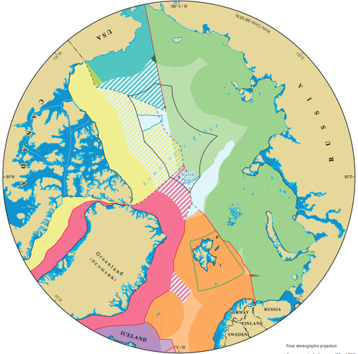
Territorial Claims
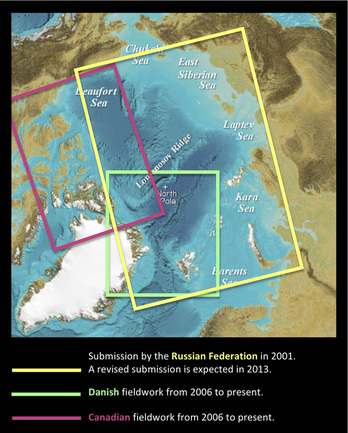
The map shows the potential areas of Canadian and Danish continental shelves beyond 200 nautical miles. The areas are theoretical maximum claims.
It appears how they overlap with the submission made by Russia to the CLCS in 2001, which Russia is currently revising.
It appears how they overlap with the submission made by Russia to the CLCS in 2001, which Russia is currently revising.
International Boundaries Research Unit, Durham University


The Lomonosov Ridge is not very precisely marked on the map, and it is therefore difficult to determine how the territorial claims overlap on the specific ridge.
A closer look at the technical maps made by GEUS - the Danish institute for geological surveys - shows that the Russian claim collides with the Danish one regarding the Lomonosov Ridge close to the point of the North Pole, and the Canadian investigation of the Lomonsov Ridge overlaps the Danish ones at the southern end of the ridge.
A closer look at the technical maps made by GEUS - the Danish institute for geological surveys - shows that the Russian claim collides with the Danish one regarding the Lomonosov Ridge close to the point of the North Pole, and the Canadian investigation of the Lomonsov Ridge overlaps the Danish ones at the southern end of the ridge.
Russian claim in 2001
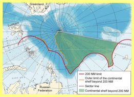
The Russian Federation submitted a claim in 2001. The CLCS, however, recommended a revised submission, which the Russians are expected to submit in 2013 or 2014. The Russian claim from 2001 included the part of the Lomonosov Ridge which extends from the Russian coast until the point of the North Pole.
The Danish claim (expected 2014)
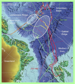
Danish bathymetric and seismic investigations planned to be collected in 2012. The smallest white circle appears encircles a southern part of the Lomonosov Ridge. The orange stippled line between the white circle and Greenland represents seismic data from 2006.
The Canadian claim (expected 2013)
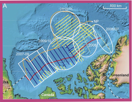
The map shows Canadian bathymetric and seismic investigations of the southern end of the Lomonosov Ridge (the rightmost white circle).
