Article 76
This page show a document analysis of the Article 76 of the UNCLOS.
The green highlighted words in the document are explained to the left next to the article. As described bellow the document, the explained words are central to the scientific facts needed in order to argue for the extension of the outer limit of the continental shelf.
The green highlighted words in the document are explained to the left next to the article. As described bellow the document, the explained words are central to the scientific facts needed in order to argue for the extension of the outer limit of the continental shelf.
| 
The legal definition of the continental shelf is the outer edge of the continental margin. The continental shelf comprises the seabed and the subsoil of the natural prolongation of its land territory (continental margin), or to a distance of 200 nautical miles where the outer edge of the continental margin does not extend up to that distance.

The continental margin is constituted by the seabed and subsoil of the shelf, the slope and the rise. The continental margin is the submerged prolongation of its landmass.
The continental margin is determined scientifically by way of formula or constraint lines. 
An ocean ridge is part of the deep ocean floor and cannot be claimed as sovereign territory, since it by definition is not part of a landmass.

The foot of the continental slope (FOS) is a point measured by maximum chance of gradient at the base of the continental slope.

Submarine ridges are part of the continental shelf, but they are not natural components of the continental margin because they are not submarine elevations. Distinctions between submarine ridges and submarine elevations are measured by morphologic, geologic and tectonic methods.

Submarine elevations are components of the continental margin (and can be either oceanic or continental in origin) if there exists a continuity of morphological or geologic origin and history to the coastal state landmass.
|
Measuring the Continental Margin
In order to settle the continental shelf legally, the continental margin must be identified scientifically.
There are overall two methods (formula and constraint) by which the continental margin can be identified. Of each method there are further two ways of conduction.
Formula
There are two means by which a formula line can be identified.
There are overall two methods (formula and constraint) by which the continental margin can be identified. Of each method there are further two ways of conduction.
Formula
There are two means by which a formula line can be identified.
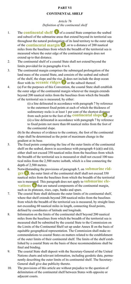
- To map the foot of the continental slope + adding 60 nautical miles.
- To measure the thickness of the sedimentary layer which must be at least one per cent of the distance to the FOS.
- 350 nautical miles from baseline (shoreline)
- 2,500 meters isobath (depth of sea level to sea bottom)
The importance of article 76 to the Lomonosov Ridge
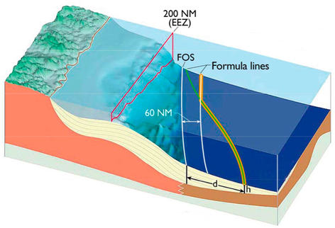
Article 76 (5) makes it clear that the maximum limit in regard to the possible extension of continental shelves can be determined in two ways: the fixed points must not exceed 350 nautical miles from the baselines, or they must not exceed 100 nautical miles from the 2,500 meters isobaths. It is up to the coastal state to choose the more favourable method in determining the outer limit of a coastal State’s continental shelf. A combination of the methods results in two “donut holes”, which lay beyond the coastal shelves of the five coastal states. The role of “submarine elevations” Article 76 (6) enables an extension of a continental shelf beyond what is possible following the 350 nautical miles claim or the 2,500 meters isobaths + 100 nautical miles. The sticking point is whether the Lomonosov Ridge classifies as a so-called “submarine ridges” and “submarine elevations”. If a continental shelf covers a “submarine ridge”, the outer limit is delimited by the 350 nautical miles. If, however, the Lomonosov Ridge appears to be a “submarine elevation” it may be claimed as sovereign territory, since paragraph 6 states that the maximum seaward limit of the 350 nautical miles does not apply for “submarine elevations”. What is the Lomonosov Ridge? It is thus crucial for Russians, Danes and Canadian to prove first of all that the Lomonosov Ridge is not an “ocean ridge”, in which case it would be located beyond the limits of areas under national jurisdiction, since oceanic ridges are part of the deep ocean floor. Secondly, it is important to prove that it is not a “submarine ridge”, in which case it would indeed classify as a prolongation of land-mass, but it would nevertheless be out of reach for the coastal states due to the maximum seaward limit of 350 nautical miles. If, however, proofs are found that the Lomonosov Ridge is a “submarine elevation” of one of the coastal states, the ridge counts as part of the continental margin of the concerned state, and is thereby no longer bound by the maximum seaward limit. >> | 
The figure is from Macnab et al. (2001) an shows the two areas, which are not yet occupied by the five Costal States if they extend their continental shelves by combining the 350nm limit with the 2,500 isobath plus 100nm method.
>> It is not entirely clear from paragraph 6, what the difference is between a “submarine elevation” and a “submarine ridge”. But since both are part of the continental margin – otherwise they would be “oceanic ridges” – they must be a geological continuation of the landmass of the coastal State. If the seafloor high in question belongs to one continental plate, it might reveal whether it counts as a “submarine ridge” or a “submarine elevation”. A “submarine elevation” is a natural component of the continental plate, sharing its genetic and morphological structure. A “submarine ridge” might share the genetic and morphological structure of the continental plate, but is nevertheless not a “submarine elevation” if geological characteristics are found that links it with the deep seabed (e.g. volcanic activities). |
