• Introduction
  • Actors, Networks & Issues
    • The Arctic Issue on the Web
      • The Scientific Issue Network
        • Timeline
        • Lomonosov Ridge
          • Territorial claims
            • Scientific methods
              • Rhetorical Claims
              • Legal context
                • UNCLOS & CLCS
                  • Article 76
                    • Fact System
                      • From Claim to Right>
                        • GEUS article
                          • Aerogeophysical study
                        • About
                          • About us
                          The Right Arctic

                          Scientific Methods

                          This page visualizes the scientific instruments that are used when conducting research at the bottom of the Arctic seabed and ocean floor. By showing the equipment and the role of scientific instruments, we wish to draw attention to the knowledge production behind scientific facts. The instruments produce the scientific facts in such a way that they fit with the particular Fact System, in which they are to enter.  
                          The central scientific techniques
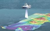
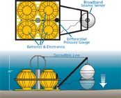
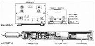
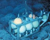
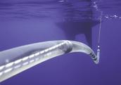
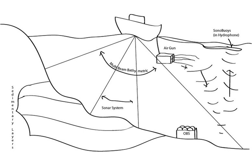
                          The drawing below shows what goes on beneath the sea surface of the icebreaker. By sketching the functions of the central machines that are brought along on the scientific expeditions in the Arctic, it will be possible to understand the process of scientific knowledge production. Scientists of several fields have participated in the different expeditions - among others geophysicists, geologists and biologists.

                          We have included pictures of each instrument as it look to the naked eye as well as to the scientists (inside the machine). The machines are described by their function during the expeditions and related to the methods and types of measurement they do.

                          Picture
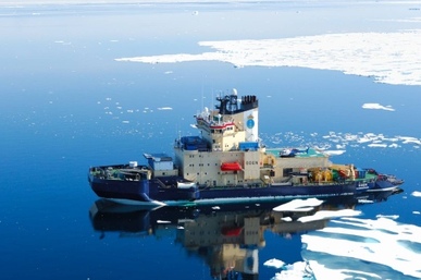
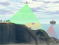
                          Oden - the Swedish icebreaker that led the scientific expeditions on the Arctic: LOMROG 2007 & LOMROG II in 2009. (Illustration from www.a76.dk)
                          Picture
                          Bathymetric data

                          Multi Beam Bathymetry
                          The multi beam bathymetry measure with a wide of up till five times the length of the boat. It exposes the morphology of the seabed by measuring the depth from sea level to seabed.

                          Sonar System
                          The sonar system is also illustrated by the first picture of the multi beam bathymetric method, as sonar likewise is being conducted from under the boat to sea bed. The sonar will characterize the first 50 - 200 m. of the sedimentary layer.

                          Seismic data

                          Ocean Bottom Seisometer (OBS)
                          The Ocean Bottom Seisometer measures the speed and energy of waves from earthquakes passed through layers of materials inside the earth. The OBS is needed in order to calculate the structure of the earth's mantle and crust.
                          Sonobuoys
                          The Sonobuoys inside the hydrophone is dragged behind the boat just beneath the sea surface. The Sonobuoys receives sound waves that are projected from the sea bottom. The Air Gun (see drawing above) sends out high pressure of air in order to create sound waves that go to the sea bottom and hereafter return to sea surface. Seismic data are used in order to identify the sedimentary layers by thickness and structure.

                          Multi beam bathymetric method

                          Picture


                          (Illustration: https://www.e-education.psu.edu)

                          Sonar system

                          Picture


                          (Illustration: www.gns.cri.nz)


                          Ocean Bottom Seisometer

                          Picture
                          (Illustration: http://www.whoi.edu)

                          Sonobuoys

                          Picture
                          (Illustration: www.jproc.ca)

                          Ocean Bottom Seisometer

                          Picture
                          (Illustration: www.nasa.gov)

                          Sonobuoys in hydrophone

                          Picture
                          (Illustration: http://www.isgtw.org)

                          Powered by Create your own unique website with customizable templates.