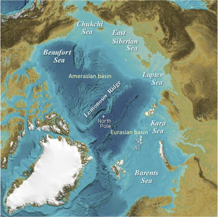
• Introduction
  • Actors, Networks & Issues
    • The Arctic Issue on the Web
      • The Scientific Issue Network
        • Timeline
        • Lomonosov Ridge
          • Territorial claims
            • Scientific methods
              • Rhetorical Claims
              • Legal context
                • UNCLOS & CLCS
                  • Article 76
                    • Fact System
                      • From Claim to Right>
                        • GEUS article
                          • Aerogeophysical study
                        • About
                          • About us
                          The Right Arctic

                          Lomonosov Ridge

                          Picture
                          Graphic from infohub.com
                          What is the Lomonosov Ridge?
                          The Lomonosov Ridge is a 1,800 km long ridge, which divides the Arctic Ocean into two major basins: the Eurasia Basin and the Amerasia Basin. The latter is more than 4,000 meters deep, whereas its Eurasian counterpart measures 3,400 meters. The ridge itself rises 1,800 - 3,400 meters from the basin floor.

                          Exploratory scope 2
                          We now dig into the scientific controversy through the specific case of the Lomonosov Ridge in order to find out how the Lomonosov Ridge becomes visible to the eye of scientists and the UN commission through a range of technical instruments. We focus on the importance of the manner in which data is constructed (validity) as well as the design of the legal territorial claims from Russia, Denmark and Canada (legitimacy).

                          Territorial claims
                          Scientific methods
                          Rhetorical claims

                          Powered by Create your own unique website with customizable templates.